


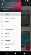
Mobile Topographer GIS


Descrizione di Mobile Topographer GIS
L'amato scelta dei professionisti,
Cellulare topografo ... meets ...
GIS .
È ora possibile eseguire una panoramica completa senza limitazioni in complessità e volume di dati.
Provare ora Mobile topografo GIS utilizzando il periodo di prova gratuito di tre giorni. Basta scaricare l'applicazione e procedere con lui procedura di iscrizione. Anche se, vi verrà chiesto di fornire dati di fatturazione, non sarà addebitato prima della fine dei tre giorni del periodo di prova gratuito. È possibile annullare l'abbonamento in qualsiasi momento durante il periodo di prova di tre giorni, a titolo gratuito. avranno luogo solo accuse, se alla fine dei tre giorni avete ancora un abbonamento attivo.
- Raccogliere le letture GNSS che utilizzano una maggiore precisione (GPS, GLONASS, Galileo, Beidou, costellazioni QZSS supportate).
- Collegare il ricevitore GNSS esterno tramite posizioni simulate e utilizzare Mobile Topogrpaher GIS come unità di elaborazione.
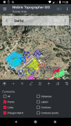
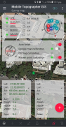
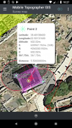
- Visualizzazione dei dati in CRS WGS84 o locale proiettata.
- Convertire da WGS84 al proiettato locali CRS e viceversa.
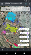
- la proiezione in tempo reale sulla mappa.
- *** NEW *** Immagine personalizzata o server WMS come mappa di sfondo.
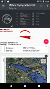
- Trovare un punto segnato nel mondo reale utilizzando "Drive me"
- altezza Calcola ortometrica al volo utilizzando il modello EGM o griglie di elevazione locali ove disponibili.
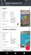
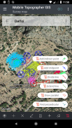
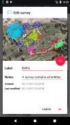
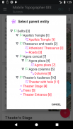
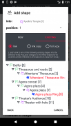
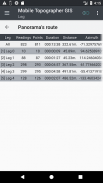
- Organizzare il lavoro in Punti - Forme - Enti e ricerche. È ora possibile creare singoli punti, gruppi multi-point, polilinee più parti, e poligoni in più parti con fori.
- Creazione di un disegno completo con tanto particolari come si desidera.
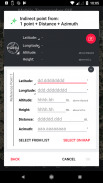
- *** NEW *** strumenti geodetici. Aggiungere punti indiretti tramite il delle seguenti opzioni: 1 punto + distanza + Azimuth, 2 punti + Distanze + Select, 2 punti + azimut, 3 punti + Distanze, punto medio della linea, linea di Divide, estendere la linea, la linea parallela, perpendicolare alla linea .
- Nest i lavori, in qualsiasi livello di nidificazione, di creare un super-sondaggio.
- Condividere i dati tra posti di lavoro con collegamenti attivi.
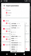
- i lavori di scambio tra il dispositivo mobile e il computer desktop, con import - funzioni di esportazione utilizzando tutti i formati più comuni txt, csv, .kml, .gpx, .dxf e Shape file (.shp - .shx - Dbf)
- Collaborare con i vostri partner di scambio e la condivisione da un punto per completare i lavori.
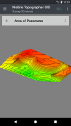
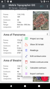
- Creare il terreno 3D di un'area semplicemente camminando attraverso di essa.
- Calcolare i contorni e aggiungerli nel vostro sondaggio con velocità lampo.
- Mostra un modello 3D reale direttamente sul dispositivo.
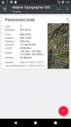
- Conservare un percorso con i suoi dati.
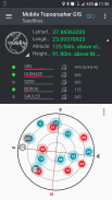
- Visualizza satelliti GNSS con informazioni del segnale sia in vista bussola o AR.
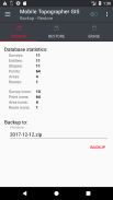
- Backup e ripristino dei dati utilizzando un file SQL Db.
Benvenuti nell'era di rilevamento mobili ...!
Trova maggiori informazioni su mobile topografo GIS in:
http://applicality.com/projects/mobile-topographer-gis/
Scarica il manuale d'uso da:
http://applicality.com/app_documentation/web/MobileTopographerGIS_Manual.pdf
Mobile Topographer GIS - Versione 6.0.15
(23-06-2023)

Mobile Topographer GIS - Informazioni APK
Versione APK: 6.0.15Pacchetto: com.applicality.mobiletopographergisUltima versione di Mobile Topographer GIS
Altre versioni


App nella stessa categoria

Potrebbe piacerti anche...


